

RIDGID SeekTech SR-24 Line Locator
RIDGID's SeekTech SR-24 Line Locator is a locating receiver that streamlines creating accurate maps of underground utilities in order to protect critical assets.
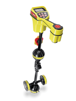 The SR-24 uses integrated Bluetooth communications to transmit locating data to either a third-party survey grade GPS or a mobile device such as a tablet or smartphone. Data logging capabilities allow recording GPS and locating data to an onboard micro SD card. In addition to impressive OmniSeek passive locating capabilities, the SR-24 can be programmed to detect any active frequency from 10 Hz to 35 kHz. Its omnidirectional antennas capture the complete signal field making it easy to locate a line and follow its path.
“The SR-24 Line Locator builds on the popular SR-20 feature set, adding GPS and wireless communication to unlock a variety of user benefits,” said Eric Huber, RIDGID Senior Product Manager. “The new features of the SR-24 allow a user to streamline the process of integrating underground utility information with GPS data.”
The free RIDGIDtrax app, for use on iPhone, iPad or Android, provides basic utility mapping on a mobile device. When paired with the SR-24 Line Locator, the RIDGIDtrax app will display GPS position and depth of the target utility on a real-time map. A user can identify the type of utility (water, gas electric, etc.) and display multiple utilities on the same map. A completed map can be saved and viewed inside the app or exported to a universal file format for use with popular GIS programs such as Google Earth.
INDUSTRIAL SUPPLY MAGAZINE


The May/June issue of Industrial Supply magazine features an in-depth cover story about GHX Industrial. Plus, we're featuring articles by contributing writers Dr. Bharani Nagarathnam and Frank Hurtte, as well as interviews with numerous product and distribution industry experts.